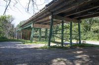
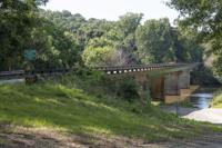
Cliff Williams / The Outlook The metal portions of the support structure of the Germany’s Ferry Bridge were painted thanks to a grant through the Rebuild Alabama Fund. The work added at least 50 years of life to the bridge.
...STRONG THUNDERSTORMS WILL IMPACT LEE...NORTHERN BULLOCK...MACON...
SOUTHEASTERN TALLAPOOSA...CHAMBERS AND WESTERN RUSSELL COUNTIES
THROUGH 530 AM CDT...

At 437 AM CDT, Doppler radar was tracking strong thunderstorms along
a line extending from Standing Rock to near Waverly to near Shopton.
Movement was east at 40 mph.

HAZARD...Wind gusts up to 50 mph.

SOURCE...Radar indicated.

IMPACT...Gusty winds could knock down tree limbs and blow around
unsecured objects.

Locations impacted include...
Auburn, Opelika, Tuskegee, Valley, Lanett, Tallassee, Union Springs,
Dadeville, Camp Hill, Notasulga, Hurtsboro, Midway, Smiths, Stroud,
Milstead, Lafayette, Smiths Station, La Fayette, Shorter, and
Franklin.

PRECAUTIONARY/PREPAREDNESS ACTIONS...

If outdoors, consider seeking shelter inside a building.

A Tornado Watch remains in effect until 900 AM CDT for south central,
southeastern and east central Alabama.

&&


MAX HAIL SIZE...0.00 IN;
MAX WIND GUST...50 MPH
...THE SEVERE THUNDERSTORM WARNING FOR SOUTHEASTERN TALLAPOOSA COUNTY
WILL EXPIRE AT 445 AM CDT...

The storms which prompted the warning have weakened below severe
limits, and no longer pose an immediate threat to life or property.
Therefore, the warning will be allowed to expire.  However, gusty
winds are still possible with these thunderstorms.

A Tornado Watch remains in effect until 900 AM CDT for southeastern
and east central Alabama.

&&
TORNADO WATCH 63 REMAINS VALID UNTIL 9 AM CDT THIS MORNING FOR
THE FOLLOWING AREAS

IN ALABAMA THIS WATCH INCLUDES 12 COUNTIES

IN CENTRAL ALABAMA

BARBOUR               BULLOCK               CHAMBERS
ELMORE                LEE                   LOWNDES
MACON                 MONTGOMERY            PIKE
RANDOLPH              RUSSELL               TALLAPOOSA

THIS INCLUDES THE CITIES OF ALEXANDER CITY, AUBURN, EUFAULA,
FORT DEPOSIT, LANETT, LOWNDESBORO, MILLBROOK, MONTGOMERY,
OPELIKA, PHENIX CITY, ROANOKE, TROY, TUSKEGEE, UNION SPRINGS,
VALLEY, AND WETUMPKA.
...WIND ADVISORY NOW IN EFFECT UNTIL 7 PM CDT THIS EVENING...
...FREEZE WARNING REMAINS IN EFFECT FROM 10 PM THIS EVENING TO 10 AM
CDT TUESDAY...

* WHAT...For the Wind Advisory, west winds 10 to 20 mph with gusts
up to 40 mph. For the Freeze Warning, sub-freezing temperatures as
low as 23 in the north and 28 in the south expected.

* WHERE...All of Central Alabama

* WHEN...For the Wind Advisory, until 7 PM CDT this evening. For the
Freeze Warning, from 10 PM this evening to 10 AM CDT Tuesday.

* IMPACTS...Gusty winds will blow around unsecured objects. Trees
could be blown down and a few power outages may result. Frost and
freeze conditions could kill crops, other sensitive vegetation and
possibly damage unprotected outdoor plumbing.

PRECAUTIONARY/PREPAREDNESS ACTIONS...

Winds this strong can make driving difficult, especially for high
profile vehicles. Use extra caution.

Secure outdoor objects.

Take steps now to protect tender plants from the cold.

To prevent freezing and possible bursting of pipes they should be
wrapped, drained, or allowed to drip slowly.

Those that have in ground sprinkler systems should drain them and
cover above ground pipes to protect them from freezing.

&&