Featured Stories
It’s not crazy to say this one is all for the marbles. That is, if the marbles are the Class 5A Region 2 crown.Â
Samuel Higgs
Sports Editor
This product covers Central Alabama TROPICAL STORM WARNING REMAINS IN EFFECT FOR SOUTHERN PORTIONS OF CENTRAL ALABAMA NEW INFORMATION --------------- * CHANGES TO WATCHES AND WARNINGS: - None * CURRENT WATCHES AND WARNINGS: - A Tropical Storm Warning is in effect for Autauga, Barbour, Bullock, Dallas, Elmore, Lowndes, Macon, Marengo, Montgomery, and Pike - A Tropical Storm Watch is in effect for Bibb, Chambers, Chilton, Clay, Coosa, Greene, Hale, Jefferson, Lee, Perry, Pickens, Randolph, Russell, Shelby, St. Clair, Sumter, Talladega, Tallapoosa, and Tuscaloosa * STORM INFORMATION: - About 610 miles south-southwest of Birmingham AL or about 540 miles south-southwest of Montgomery AL - 24.9N 88.8W - Storm Intensity 100 mph - Movement Northeast or 45 degrees at 13 mph SITUATION OVERVIEW ------------------ Hurricane Isaias will continue to move towards the Northern Gulf Coast, making landfall Friday evening. Winds will gust as high as 50 to 60+ mph late Friday night through Saturday, resulting in the potential for widespread downed trees and power lines. Rainfall amounts of 1.5 to 4 inches with locally higher amounts up to 5 inches will result in the potential for flash flooding, especially in urban and other poor drainage areas. A threat for isolated tornadoes may develop across portions of Central Alabama along and east of the track on Saturday, mainly east of Interstate 65. Confidence is low to medium at this time. POTENTIAL IMPACTS ----------------- * WIND: Protect against dangerous wind having possible significant impacts across southern portions of Central Alabama and higher elevations. Potential impacts in this area include: - Some damage to roofing and siding materials, along with damage to porches, awnings, carports, and sheds. A few buildings experiencing window, door, and garage door failures. Mobile and manufactured homes damaged, especially if unanchored. Unsecured lightweight objects become dangerous projectiles. - Several large trees snapped or uprooted. Several fences and roadway signs blown over. - Some roads impassable from large debris, and more within urban or heavily wooded places. - Scattered power and communications outages, but more prevalent in areas with above ground lines. Also, protect against hazardous wind having possible limited impacts across the rest of Central Alabama. * FLOODING RAIN: Prepare for dangerous rainfall flooding having possible significant impacts across Central Alabama. Potential impacts include: - Moderate rainfall flooding may prompt several evacuations and rescues. - Rivers and tributaries may quickly become swollen with swifter currents and overspill their banks in a few places, especially in usually vulnerable spots. Small streams, creeks, and ditches overflow. - Flood waters can enter some structures or weaken foundations. Several places may experience expanded areas of rapid inundation at underpasses, low-lying spots, and poor drainage areas. Some streets and parking lots take on moving water as storm drains and retention ponds overflow. Driving conditions become hazardous. Some road and bridge closures. * TORNADOES: Protect against a dangerous tornado event having possible significant impacts across eastern portions of Central Alabama. Potential impacts include: - Several places may experience tornado damage with a few spots of considerable damage, power loss, and communications failures. - Locations could realize roofs torn off frame houses, mobile and manufactured homes demolished, large trees snapped or uprooted, and vehicles tumbled. Dangerous projectiles can add to the toll. Elsewhere across Central Alabama, little to no impact is anticipated. PRECAUTIONARY/PREPAREDNESS ACTIONS ---------------------------------- * EVACUATIONS: Follow the advice of local officials. * OTHER PREPAREDNESS INFORMATION: Now is the time to check your emergency plan and emergency supplies kit and take necessary actions to protect your family and secure your home or business. When making safety and preparedness decisions, do not focus on the exact forecast track since hazards such as flooding rain, damaging wind gusts, and tornadoes extend well away from the center of the storm. If in a place that is vulnerable to high wind, such as near large trees or in a mobile or manufactured home, plan to move to safe shelter. If you live in a place particularly vulnerable to flooding, such as in a low-lying or poor drainage area, in a valley, or near an already swollen river, plan to move to safe shelter on higher ground. Always heed the advice of local officials and comply with orders that are issued. Do not needlessly jeopardize your life or the lives of others. When securing your property, outside preparations should be concluded as soon as possible before conditions deteriorate. The onset of strong gusty winds or flooding can cause certain preparedness activities to become unsafe. Check on those who may not be fully aware of the situation or who are unable to make personal preparations. If you are a visitor, know the name of the county in which you are located and where it is relative to current watches and warnings. If staying at a hotel, ask the management staff about their onsite disaster plan. Listen for evacuation orders, especially pertaining to area visitors. Closely monitor weather.gov, NOAA Weather Radio and local news outlets for official storm information. Listen for possible changes to the forecast. There is a threat from tornadoes with this storm. Have multiple ways to receive Tornado Warnings. Be ready to shelter quickly. * ADDITIONAL SOURCES OF INFORMATION: - For information on appropriate preparations see ready.gov - For information on creating an emergency plan see getagameplan.org - For additional disaster preparedness information see redcross.org NEXT UPDATE ----------- The next local statement will be issued by the National Weather Service in Birmingham AL around 10 PM CDT, or sooner if conditions warrant.
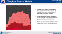
...TROPICAL STORM WATCH REMAINS IN EFFECT... * LOCATIONS AFFECTED - Alexander City - Dadeville * WIND - LATEST LOCAL FORECAST: Below tropical storm force wind - Peak Wind Forecast: 10-20 mph with gusts to 45 mph - THREAT TO LIFE AND PROPERTY THAT INCLUDES TYPICAL FORECAST UNCERTAINTY IN TRACK, SIZE AND INTENSITY: Potential for wind 39 to 57 mph - The wind threat has remained nearly steady from the previous assessment. - PLAN: Plan for hazardous wind of equivalent tropical storm force. - PREPARE: Efforts to protect property should now be underway. Prepare for limited wind damage. - ACT: Act now to complete preparations before the wind becomes hazardous. - POTENTIAL IMPACTS: Limited - Damage to porches, awnings, carports, sheds, and unanchored mobile and manufactured homes. Unsecured lightweight objects blown about. - Many large tree limbs broken off. A few trees snapped or uprooted, especially weaker trees. Some fences and roadway signs blown over. - A few roads impassable from debris, particularly within urban or heavily wooded places. Hazardous driving conditions on bridges and other elevated roadways. - Scattered power and communications outages. * FLOODING RAIN - LATEST LOCAL FORECAST: Flood Watch is in effect - Peak Rainfall Amounts: 1-3 inches, with locally higher amounts - THREAT TO LIFE AND PROPERTY THAT INCLUDES TYPICAL FORECAST UNCERTAINTY IN TRACK, SIZE AND INTENSITY: Potential for moderate flooding rain - The flooding rain threat has remained nearly steady from the previous assessment. - PLAN: Emergency plans should include the potential for moderate flooding from heavy rain. Evacuations and rescues are possible. - PREPARE: Consider protective actions if you are in an area vulnerable to flooding. - ACT: Heed any flood watches and warnings. Failure to take action may result in serious injury or loss of life. - POTENTIAL IMPACTS: Significant - Moderate rainfall flooding may prompt several evacuations and rescues. - Rivers and tributaries may quickly become swollen with swifter currents and overspill their banks in a few places, especially in usually vulnerable spots. Small streams, creeks, and ditches overflow. - Flood waters can enter some structures or weaken foundations. Several places may experience expanded areas of rapid inundation at underpasses, low-lying spots, and poor drainage areas. Some streets and parking lots take on moving water as storm drains and retention ponds overflow. Driving conditions become hazardous. Some road and bridge closures. * TORNADO - LATEST LOCAL FORECAST: - Situation is favorable for tornadoes - THREAT TO LIFE AND PROPERTY THAT INCLUDES TYPICAL FORECAST UNCERTAINTY IN TRACK, SIZE AND INTENSITY: Potential for several tornadoes - The tornado threat has remained nearly steady from the previous assessment. - PLAN: Emergency plans should include the potential for several tornadoes with a few possibly intense having larger damage paths. - PREPARE: Those living in manufactured homes or on boats should prepare to relocate to safe shelter before hazardous weather arrives. - ACT: Listen for tornado watches and warnings. If a tornado warning is issued, be ready to shelter quickly. - POTENTIAL IMPACTS: Significant - Several places may experience tornado damage with a few spots of considerable damage, power loss, and communications failures. - Locations could realize roofs torn off frame houses, mobile and manufactured homes demolished, large trees snapped or uprooted, and vehicles tumbled. Dangerous projectiles can add to the toll. * FOR MORE INFORMATION: - http://ready.gov/hurricanes
...FLOOD WATCH IN EFFECT FROM FRIDAY EVENING THROUGH SUNDAY MORNING... * WHAT...Flooding caused by excessive rainfall is possible. * WHERE...All of Central Alabama. * WHEN...From Friday evening through Sunday morning. * IMPACTS...Excessive runoff may result in flooding of rivers, creeks, streams, and other low-lying and flood-prone locations. * ADDITIONAL DETAILS... - Heavy rainfall associated with Hurricane Isaias will move into the area Friday night, and may last as long as early Sunday morning. Rainfall amounts of 2 to 4 inches with locally higher amounts up to 5 inches will result in the potential for flash flooding, especially in urban and other poor drainage areas. PRECAUTIONARY/PREPAREDNESS ACTIONS... You should monitor later forecasts and be alert for possible Flood Warnings. Those living in areas prone to flooding should be prepared to take action should flooding develop. &&
It’s not crazy to say this one is all for the marbles. That is, if the marbles are the Class 5A Region 2 crown.Â
Sports Editor
A normal traffic stop last week turned into four drug arrests.
A tropical storm watch was officially issued by the National Weather Service on Thursday morning in preparation for Hurricane Isaias, which is expected to hit landfall sometime Friday.
In an old family and church cemetery tucked away on a county road in Coosa County, a member of the Revolutionary War militia was recognized after 250 years.
Central Coosa High School Pride of Coosa County band racked up a few big awards.
Gov. Kay Ivey has issued a state of emergency for 40 counties as Alabama prepares for possible impact from the tropical system in the Gulf, Isaias. All three local counties — Tallapoosa, Coosa…
Tallapoosa County Extension Service director Shane Harris acknowledges his expertise isn’t mental health or home economics.
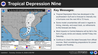
According to a weather briefing from the National Weather Service, Central Alabama should prepare as Tropical Storm Isaias approaches the Gulf.Â
Students at Central Alabama Community College will benefit from expanded transfer opportunities and scholarship support under a new memorandum of understanding signed with Jacksonville State U…
It’s not crazy to say this one is all for the marbles. That is, if the marbles are the Class 5A Region 2 crown.Â
Friday night has a certain je ne sais quoi.
Tropical Storm Isaias is set to make landfall this weekend, and make its way through the state of Alabama. The impending inclement weather has caused a plethora of games in the state to push t…
Benjamin Russell may have taken the first set Thursday night against Wetumpka in a close affair. But that is when Wetumpka took over and won 3-1.
Reeltown had that one circled, quite literally.
It got to a point on Thursday night where immediately after a play was run, a yellow marker would greet the Central Coosa football team.Â
For local author Anthony Baldwin, old folk tales give him inspiration for his novels.
Three local arts programs will be receiving funding from the Alabama State Council on the Arts.
It was a night that won’t be forgotten as Laurel Taunton Taylor brought Butter & Grit to the Mt. Vernon Performing Arts Center Stage Saturday night.
This product covers Central Alabama TROPICAL STORM WARNING REMAINS IN EFFECT FOR SOUTHERN PORTIONS OF CENTRAL ALABAMA NEW INFORMATION --------------- * CHANGES TO WATCHES AND WARNINGS: - None * CURRENT WATCHES AND WARNINGS: - A Tropical Storm Warning is in effect for Autauga, Barbour, Bullock, Dallas, Elmore, Lowndes, Macon, Marengo, Montgomery, and Pike - A Tropical Storm Watch is in effect for Bibb, Chambers, Chilton, Clay, Coosa, Greene, Hale, Jefferson, Lee, Perry, Pickens, Randolph, Russell, Shelby, St. Clair, Sumter, Talladega, Tallapoosa, and Tuscaloosa * STORM INFORMATION: - About 610 miles south-southwest of Birmingham AL or about 540 miles south-southwest of Montgomery AL - 24.9N 88.8W - Storm Intensity 100 mph - Movement Northeast or 45 degrees at 13 mph SITUATION OVERVIEW ------------------ Hurricane Isaias will continue to move towards the Northern Gulf Coast, making landfall Friday evening. Winds will gust as high as 50 to 60+ mph late Friday night through Saturday, resulting in the potential for widespread downed trees and power lines. Rainfall amounts of 1.5 to 4 inches with locally higher amounts up to 5 inches will result in the potential for flash flooding, especially in urban and other poor drainage areas. A threat for isolated tornadoes may develop across portions of Central Alabama along and east of the track on Saturday, mainly east of Interstate 65. Confidence is low to medium at this time. POTENTIAL IMPACTS ----------------- * WIND: Protect against dangerous wind having possible significant impacts across southern portions of Central Alabama and higher elevations. Potential impacts in this area include: - Some damage to roofing and siding materials, along with damage to porches, awnings, carports, and sheds. A few buildings experiencing window, door, and garage door failures. Mobile and manufactured homes damaged, especially if unanchored. Unsecured lightweight objects become dangerous projectiles. - Several large trees snapped or uprooted. Several fences and roadway signs blown over. - Some roads impassable from large debris, and more within urban or heavily wooded places. - Scattered power and communications outages, but more prevalent in areas with above ground lines. Also, protect against hazardous wind having possible limited impacts across the rest of Central Alabama. * FLOODING RAIN: Prepare for dangerous rainfall flooding having possible significant impacts across Central Alabama. Potential impacts include: - Moderate rainfall flooding may prompt several evacuations and rescues. - Rivers and tributaries may quickly become swollen with swifter currents and overspill their banks in a few places, especially in usually vulnerable spots. Small streams, creeks, and ditches overflow. - Flood waters can enter some structures or weaken foundations. Several places may experience expanded areas of rapid inundation at underpasses, low-lying spots, and poor drainage areas. Some streets and parking lots take on moving water as storm drains and retention ponds overflow. Driving conditions become hazardous. Some road and bridge closures. * TORNADOES: Protect against a dangerous tornado event having possible significant impacts across eastern portions of Central Alabama. Potential impacts include: - Several places may experience tornado damage with a few spots of considerable damage, power loss, and communications failures. - Locations could realize roofs torn off frame houses, mobile and manufactured homes demolished, large trees snapped or uprooted, and vehicles tumbled. Dangerous projectiles can add to the toll. Elsewhere across Central Alabama, little to no impact is anticipated. PRECAUTIONARY/PREPAREDNESS ACTIONS ---------------------------------- * EVACUATIONS: Follow the advice of local officials. * OTHER PREPAREDNESS INFORMATION: Now is the time to check your emergency plan and emergency supplies kit and take necessary actions to protect your family and secure your home or business. When making safety and preparedness decisions, do not focus on the exact forecast track since hazards such as flooding rain, damaging wind gusts, and tornadoes extend well away from the center of the storm. If in a place that is vulnerable to high wind, such as near large trees or in a mobile or manufactured home, plan to move to safe shelter. If you live in a place particularly vulnerable to flooding, such as in a low-lying or poor drainage area, in a valley, or near an already swollen river, plan to move to safe shelter on higher ground. Always heed the advice of local officials and comply with orders that are issued. Do not needlessly jeopardize your life or the lives of others. When securing your property, outside preparations should be concluded as soon as possible before conditions deteriorate. The onset of strong gusty winds or flooding can cause certain preparedness activities to become unsafe. Check on those who may not be fully aware of the situation or who are unable to make personal preparations. If you are a visitor, know the name of the county in which you are located and where it is relative to current watches and warnings. If staying at a hotel, ask the management staff about their onsite disaster plan. Listen for evacuation orders, especially pertaining to area visitors. Closely monitor weather.gov, NOAA Weather Radio and local news outlets for official storm information. Listen for possible changes to the forecast. There is a threat from tornadoes with this storm. Have multiple ways to receive Tornado Warnings. Be ready to shelter quickly. * ADDITIONAL SOURCES OF INFORMATION: - For information on appropriate preparations see ready.gov - For information on creating an emergency plan see getagameplan.org - For additional disaster preparedness information see redcross.org NEXT UPDATE ----------- The next local statement will be issued by the National Weather Service in Birmingham AL around 10 PM CDT, or sooner if conditions warrant.
...TROPICAL STORM WATCH REMAINS IN EFFECT... * LOCATIONS AFFECTED - Alexander City - Dadeville * WIND - LATEST LOCAL FORECAST: Below tropical storm force wind - Peak Wind Forecast: 10-20 mph with gusts to 45 mph - THREAT TO LIFE AND PROPERTY THAT INCLUDES TYPICAL FORECAST UNCERTAINTY IN TRACK, SIZE AND INTENSITY: Potential for wind 39 to 57 mph - The wind threat has remained nearly steady from the previous assessment. - PLAN: Plan for hazardous wind of equivalent tropical storm force. - PREPARE: Efforts to protect property should now be underway. Prepare for limited wind damage. - ACT: Act now to complete preparations before the wind becomes hazardous. - POTENTIAL IMPACTS: Limited - Damage to porches, awnings, carports, sheds, and unanchored mobile and manufactured homes. Unsecured lightweight objects blown about. - Many large tree limbs broken off. A few trees snapped or uprooted, especially weaker trees. Some fences and roadway signs blown over. - A few roads impassable from debris, particularly within urban or heavily wooded places. Hazardous driving conditions on bridges and other elevated roadways. - Scattered power and communications outages. * FLOODING RAIN - LATEST LOCAL FORECAST: Flood Watch is in effect - Peak Rainfall Amounts: 1-3 inches, with locally higher amounts - THREAT TO LIFE AND PROPERTY THAT INCLUDES TYPICAL FORECAST UNCERTAINTY IN TRACK, SIZE AND INTENSITY: Potential for moderate flooding rain - The flooding rain threat has remained nearly steady from the previous assessment. - PLAN: Emergency plans should include the potential for moderate flooding from heavy rain. Evacuations and rescues are possible. - PREPARE: Consider protective actions if you are in an area vulnerable to flooding. - ACT: Heed any flood watches and warnings. Failure to take action may result in serious injury or loss of life. - POTENTIAL IMPACTS: Significant - Moderate rainfall flooding may prompt several evacuations and rescues. - Rivers and tributaries may quickly become swollen with swifter currents and overspill their banks in a few places, especially in usually vulnerable spots. Small streams, creeks, and ditches overflow. - Flood waters can enter some structures or weaken foundations. Several places may experience expanded areas of rapid inundation at underpasses, low-lying spots, and poor drainage areas. Some streets and parking lots take on moving water as storm drains and retention ponds overflow. Driving conditions become hazardous. Some road and bridge closures. * TORNADO - LATEST LOCAL FORECAST: - Situation is favorable for tornadoes - THREAT TO LIFE AND PROPERTY THAT INCLUDES TYPICAL FORECAST UNCERTAINTY IN TRACK, SIZE AND INTENSITY: Potential for several tornadoes - The tornado threat has remained nearly steady from the previous assessment. - PLAN: Emergency plans should include the potential for several tornadoes with a few possibly intense having larger damage paths. - PREPARE: Those living in manufactured homes or on boats should prepare to relocate to safe shelter before hazardous weather arrives. - ACT: Listen for tornado watches and warnings. If a tornado warning is issued, be ready to shelter quickly. - POTENTIAL IMPACTS: Significant - Several places may experience tornado damage with a few spots of considerable damage, power loss, and communications failures. - Locations could realize roofs torn off frame houses, mobile and manufactured homes demolished, large trees snapped or uprooted, and vehicles tumbled. Dangerous projectiles can add to the toll. * FOR MORE INFORMATION: - http://ready.gov/hurricanes
...FLOOD WATCH IN EFFECT FROM FRIDAY EVENING THROUGH SUNDAY MORNING... * WHAT...Flooding caused by excessive rainfall is possible. * WHERE...All of Central Alabama. * WHEN...From Friday evening through Sunday morning. * IMPACTS...Excessive runoff may result in flooding of rivers, creeks, streams, and other low-lying and flood-prone locations. * ADDITIONAL DETAILS... - Heavy rainfall associated with Hurricane Isaias will move into the area Friday night, and may last as long as early Sunday morning. Rainfall amounts of 2 to 4 inches with locally higher amounts up to 5 inches will result in the potential for flash flooding, especially in urban and other poor drainage areas. PRECAUTIONARY/PREPAREDNESS ACTIONS... You should monitor later forecasts and be alert for possible Flood Warnings. Those living in areas prone to flooding should be prepared to take action should flooding develop. &&
Currently in Alexander City
Fall is in the air. Well astronomical fall is, but not so much in temperature.
It’s no secret everyone uses some form of artificial intelligence. Whether it be these new AI graphics that you see popping up all over Facebook or something more simple like the GPS capabilities on your phone, there’s AI everywhere. And it’s been around for a long time.
Sticks and stones may break my bones but words will never hurt me.
Elmer Adams, age 83, of Trumbull, passed away peacefully on Sunday, September 6, 2026, at Br…
Rickey Thomas Montz, a beloved father, son, and cherished member of his family, passed away …
Mary Louenna Pearson Taylor passed away on the evening of Friday, August 28, 2026, at the ag…
Sorry, an error occurred.
Already Subscribed!
Cancel anytime
Thank you .
Your account has been registered, and you are now logged in.
Check your email for details.
Submitting this form below will send a message to your email with a link to change your password.
An email message containing instructions on how to reset your password has been sent to the email address listed on your account.
No promotional rates found.
Secure & Encrypted
Thank you.
Your gift purchase was successful! Your purchase was successful, and you are now logged in.
| Rate: | |
| Begins: | |
| Transaction ID: |
A receipt was sent to your email.