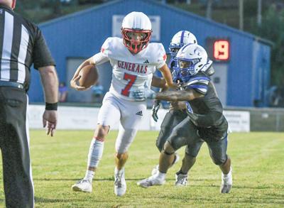
Samuel Higgs / TPI Horseshoe Bend's Jady Long (7) emerges as a threat in the backfield after an injury to Braxton Wilson. The Generals are still in serach of their first win of the season.
Samuel Higgs / TPI Horseshoe Bend's Jady Long (7) emerges as a threat in the backfield after an injury to Braxton Wilson. The Generals are still in serach of their first win of the season.
It has not been pretty for the Horseshoe Bend Generals through the first six weeks of the season.
Currently, Horseshoe Bend sits at 0-5, going 0-2 in Class 2A Region 4 games thus far. Last week, it fell 40-7 to White Plains with freshman Jady Long emerging in the backfield in place of an injured Braxton Wilson.
TORNADO WATCH 63 REMAINS VALID UNTIL 9 AM CDT THIS MORNING FOR
THE FOLLOWING AREAS

IN ALABAMA THIS WATCH INCLUDES 14 COUNTIES

IN CENTRAL ALABAMA

BARBOUR               BULLOCK               CHAMBERS
CLAY                  CLEBURNE              ELMORE
LEE                   LOWNDES               MACON
MONTGOMERY            PIKE                  RANDOLPH
RUSSELL               TALLAPOOSA

THIS INCLUDES THE CITIES OF ALEXANDER CITY, ASHLAND, AUBURN,
EUFAULA, FORT DEPOSIT, HEFLIN, LANETT, LINEVILLE, LOWNDESBORO,
MILLBROOK, MONTGOMERY, OPELIKA, PHENIX CITY, ROANOKE, TROY,
TUSKEGEE, UNION SPRINGS, VALLEY, AND WETUMPKA.
...STRONG THUNDERSTORMS WILL IMPACT TALLAPOOSA...CHAMBERS AND EASTERN
COOSA COUNTIES THROUGH 445 AM CDT...

At 344 AM CDT, Doppler radar was tracking strong thunderstorms along
a line extending from 6 miles west of Goldville to near Highway 9 and
Highway 22 to Speed. Movement was east at 40 mph.

HAZARD...Wind gusts up to 50 mph.

SOURCE...Radar indicated.

IMPACT...Gusty winds could knock down tree limbs and blow around
unsecured objects.

Locations impacted include...
Alexander City, Dadeville, Goodwater, Camp Hill, Kellyton, Equality,
Stroud, Lafayette, La Fayette, Jacksons' Gap, New Site, Waverly, Five
Points, Goldville, Sturkie, Trammel Crossroads, Buffalo, Hillabee
Creek, Western Lake Martin, and Highway 9 and Highway 22.

PRECAUTIONARY/PREPAREDNESS ACTIONS...

If outdoors, consider seeking shelter inside a building.

A Tornado Watch remains in effect until 400 AM CDT for east central
Alabama. A Tornado Watch also remains in effect until 900 AM CDT for
east central Alabama.

&&


MAX HAIL SIZE...0.00 IN;
MAX WIND GUST...50 MPH
...WIND ADVISORY NOW IN EFFECT UNTIL 7 PM CDT THIS EVENING...
...FREEZE WARNING REMAINS IN EFFECT FROM 10 PM THIS EVENING TO 10 AM
CDT TUESDAY...

* WHAT...For the Wind Advisory, west winds 10 to 20 mph with gusts
up to 40 mph. For the Freeze Warning, sub-freezing temperatures as
low as 23 in the north and 28 in the south expected.

* WHERE...All of Central Alabama

* WHEN...For the Wind Advisory, until 7 PM CDT this evening. For the
Freeze Warning, from 10 PM this evening to 10 AM CDT Tuesday.

* IMPACTS...Gusty winds will blow around unsecured objects. Trees
could be blown down and a few power outages may result. Frost and
freeze conditions could kill crops, other sensitive vegetation and
possibly damage unprotected outdoor plumbing.

PRECAUTIONARY/PREPAREDNESS ACTIONS...

Winds this strong can make driving difficult, especially for high
profile vehicles. Use extra caution.

Secure outdoor objects.

Take steps now to protect tender plants from the cold.

To prevent freezing and possible bursting of pipes they should be
wrapped, drained, or allowed to drip slowly.

Those that have in ground sprinkler systems should drain them and
cover above ground pipes to protect them from freezing.

&&


