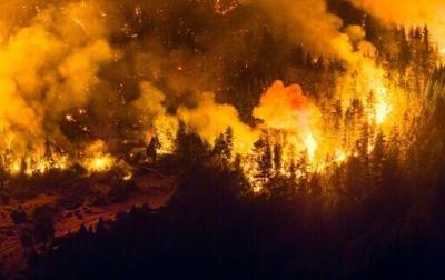
Argentina's government on Thursday declared an emergency in Patagonia, where wildfires have ripped through vast tracts of forest since the start of the Southern Hemisphere summer.
The biggest blazes are in southern Chubut province, where at least 45,000 hectares of forest -- an area roughly the size of San Francisco -- have gone up in smoke since mid-January.
...EXTREME COLD WARNING REMAINS IN EFFECT UNTIL NOON CST SUNDAY...
...WIND ADVISORY REMAINS IN EFFECT UNTIL 9 PM CST THIS EVENING...

* WHAT...For the Extreme Cold Warning, dangerously cold wind chills
as low as 3 below to 5 above. For the Wind Advisory, northwest
winds 15 to 20 mph with gusts up to 40 mph.

* WHERE...Barbour, Bullock, Calhoun, Chambers, Cherokee, Clay,
Cleburne, Coosa, Elmore, Lee, Macon, Montgomery, Pike, Randolph,
Russell, Talladega, and Tallapoosa Counties.

* WHEN...For the Extreme Cold Warning, until noon CST Sunday. For
the Wind Advisory, until 9 PM CST this evening.

* IMPACTS...Gusty winds will blow around unsecured objects. Trees
could be blown down and a few power outages may result. Frostbite
and hypothermia will occur if unprotected skin is exposed to these
temperatures. An extended period of subfreezing temperatures could
cause pipes to burst.

PRECAUTIONARY/PREPAREDNESS ACTIONS...

Winds this strong can make driving difficult, especially for high
profile vehicles. Use extra caution.

Secure outdoor objects.

Dress in layers including a hat, face mask, and gloves if you must
go outside.

Keep pets indoors as much as possible.

Make frequent checks on older family, friends, and neighbors. Ensure
portable heaters are used correctly. Do not use generators or grills
inside.

To prevent freezing and possible bursting of pipes they should be
wrapped, drained, or allowed to drip slowly.

&&