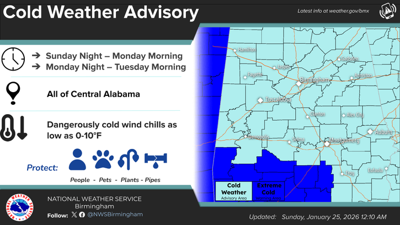
According to Tallapoosa County Emergency Management director Jason Moran, an additional warming station will be open in Alexander City.
Submitted / TPI
The Family Worship Center, located at 427 Church St., will open tonight from 7 p.m.-7 a.m. and again on Monday night from 7 p.m.-7 a.m. Mount Lovely Baptist Church in Camp Hill will open but details are unavailable at this time.
...A STRONG THUNDERSTORM WILL IMPACT TALLADEGA...EAST CENTRAL
SHELBY...NORTHWESTERN TALLAPOOSA...NORTHEASTERN COOSA AND SOUTHERN
CLAY COUNTIES THROUGH 645 PM CDT...

At 558 PM CDT, Doppler radar was tracking a strong thunderstorm over
Winterboro, or 9 miles northeast of Sylacauga. This thunderstorm was
nearly stationary.

HAZARD...Wind gusts up to 50 mph.

SOURCE...Radar indicated.

IMPACT...Gusty winds could knock down tree limbs and blow around
unsecured objects.

Locations impacted include...
Talladega, Sylacauga, Childersburg, Ashland, Wilsonville, Goodwater,
Stewartville, Vincent, Harpersville, Oak Grove, Waldo, Bon Air,
Goldville, Alpine Bay Resort, Winterboro, Strickland Crossroads,
Fayetteville, Alpine, Sycamore, and Parkdale.

PRECAUTIONARY/PREPAREDNESS ACTIONS...

If outdoors, consider seeking shelter inside a building.

Frequent cloud to ground lightning is occurring with this storm.
Lightning can strike 10 miles away from a thunderstorm. Seek a safe
shelter inside a building or vehicle.

A Severe Thunderstorm Watch remains in effect until 800 PM CDT for
central and east central Alabama.

&&


MAX HAIL SIZE...0.00 IN;
MAX WIND GUST...50 MPH
...HEAT ADVISORY REMAINS IN EFFECT UNTIL 9 PM CDT THURSDAY...

* WHAT...Heat index values up to 109.

* WHERE...Autauga, Calhoun, Coosa, Dallas, Elmore, Lowndes, Marengo,
Montgomery, Talladega, and Tallapoosa Counties.

* WHEN...Until 9 PM CDT Thursday.

* IMPACTS...Hot temperatures and high humidity may cause heat
illnesses.

PRECAUTIONARY/PREPAREDNESS ACTIONS...

Drink plenty of fluids, stay in an air-conditioned room, stay out of
the sun, and check up on relatives and neighbors. Young children and
pets should never be left unattended in vehicles under any
circumstances.

Take extra precautions if you work or spend time outside. When
possible, reschedule strenuous activities to early morning or
evening. Know the signs and symptoms of heat exhaustion and heat
stoke. Wear light weight and loose fitting clothing when possible
and drink plenty of water.

To reduce risk during outdoor work, the Occupational Safety and
Health Administration recommends scheduling frequent rest breaks in
shaded or air conditioned environments. Anyone overcome by heat
should be moved to a cool and shaded location. Heat stroke is an
emergency! Call 9 1 1.

&&
THE NATIONAL WEATHER SERVICE HAS ISSUED SEVERE THUNDERSTORM WATCH
430 IN EFFECT UNTIL 8 PM CDT THIS EVENING FOR THE FOLLOWING AREAS

IN ALABAMA THIS WATCH INCLUDES 31 COUNTIES

IN CENTRAL ALABAMA

AUTAUGA               BIBB                  BLOUNT
CALHOUN               CHAMBERS              CHEROKEE
CHILTON               CLAY                  CLEBURNE
COOSA                 DALLAS                ELMORE
ETOWAH                FAYETTE               GREENE
HALE                  JEFFERSON             LAMAR
MARENGO               MARION                PERRY
PICKENS               RANDOLPH              SHELBY
ST. CLAIR             SUMTER                TALLADEGA
TALLAPOOSA            TUSCALOOSA            WALKER
WINSTON

THIS INCLUDES THE CITIES OF ALABASTER, ALEXANDER CITY,
ALICEVILLE, ANNISTON, ASHLAND, BIRMINGHAM, BRENT, CARROLLTON,
CENTRE, CENTREVILLE, CLANTON, COLUMBIANA, DEMOPOLIS, EUTAW,
FAYETTE, GADSDEN, GREENSBORO, HALEYVILLE, HAMILTON, HEFLIN,
HOOVER, JACKSONVILLE, JASPER, LANETT, LINDEN, LINEVILLE,
LIVINGSTON, MARION, MILLBROOK, MOODY, MOUNDVILLE, ONEONTA,
PELHAM, PELL CITY, PRATTVILLE, ROANOKE, ROCKFORD, SELMA,
SULLIGENT, SYLACAUGA, TALLADEGA, TUSCALOOSA, UNIONTOWN, VALLEY,
VERNON, WETUMPKA, AND YORK.


