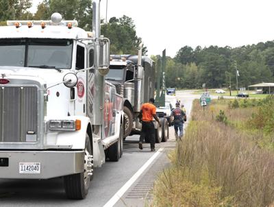
Cliff Williams / The Outlook A tow truck readies a log truck for removal after the log truck broke down on Highway 22 near Highway 9 Thursday. The truck had a fuel leak and labout 60 gallons of fuel escaped from the truck. No one was hurt in the incident.
Cliff Williams / The Outlook A tow truck readies a log truck for removal after the log truck broke down on Highway 22 near Highway 9 Thursday. The truck had a fuel leak and labout 60 gallons of fuel escaped from the truck. No one was hurt in the incident.
A tow truck readies a log truck for removal after the log truck broke down on Highway 22 near Highway 9 Thursday. The truck had a fuel leak and labout 60 gallons of fuel escaped from the truck. No one was hurt in the incident.
Cliff Williams is a staff writer for Tallapoosa Publishers.
...STRONG THUNDERSTORMS WILL IMPACT NORTHWESTERN TALLAPOOSA...
NORTHEASTERN COOSA AND CLAY COUNTIES THROUGH 815 PM CDT...

At 722 PM CDT, Doppler radar was tracking strong thunderstorms along
a line extending from near Mount Cheaha to 6 miles east of Sycamore
to Strickland Crossroads. Movement was east at 20 mph.

HAZARD...Wind gusts up to 50 mph.

SOURCE...Radar indicated.

IMPACT...Gusty winds could knock down tree limbs and blow around
unsecured objects.

Locations impacted include...
Lineville, Ashland, Goodwater, Stewartville, New Site, Goldville,
Hanover, Bradford, Barfield, Parkdale, Delta, Hatchet, Cleveland
Crossroads, Cragford, Hollins, Hackneyville, Motley, Roselle,
Millerville, and Mellow Valley.

PRECAUTIONARY/PREPAREDNESS ACTIONS...

If outdoors, consider seeking shelter inside a building.

Torrential rainfall is also occurring with these storms and may lead
to localized flooding. Do not drive your vehicle through flooded
roadways.

Frequent cloud to ground lightning is occurring with these storms.
Lightning can strike 10 miles away from a thunderstorm. Seek a safe
shelter inside a building or vehicle.

&&


MAX HAIL SIZE...0.00 IN;
MAX WIND GUST...50 MPH