Safer places to shelter have opened across Tallapoosa County in preparation for the incoming severe weather and potential flooding.
All community FEMA safe rooms, including Camp Hill, Daviston, Hackneyville, Jackson’s Gap, Tallassee and Union, are open as well as Jackson’s Gap Town Hall basement, which is a safer place.
THE NATIONAL WEATHER SERVICE HAS ISSUED TORNADO WATCH 354 IN
EFFECT UNTIL 10 PM CDT THIS EVENING FOR THE FOLLOWING AREAS

IN ALABAMA THIS WATCH INCLUDES 5 COUNTIES

IN CENTRAL ALABAMA

CHAMBERS              ELMORE                LEE
RANDOLPH              TALLAPOOSA

THIS INCLUDES THE CITIES OF ALEXANDER CITY, AUBURN, LANETT,
MILLBROOK, OPELIKA, ROANOKE, VALLEY, AND WETUMPKA.
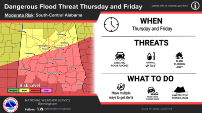
...FLOOD WATCH REMAINS IN EFFECT THROUGH FRIDAY EVENING...

* WHAT...Flash flooding caused by excessive rainfall continues to be
possible.

* WHERE...A portion of central Alabama, including the following
counties, Autauga, Barbour, Bibb, Bullock, Calhoun, Chambers,
Chilton, Clay, Cleburne, Coosa, Dallas, Elmore, Greene, Hale,
Jefferson, Lee, Lowndes, Macon, Marengo, Montgomery, Perry,
Pickens, Pike, Randolph, Russell, Shelby, St. Clair, Sumter,
Talladega, Tallapoosa and Tuscaloosa.

* WHEN...Through Friday evening.

* IMPACTS...Excessive runoff may result in flooding of rivers,
creeks, streams, and other low-lying and flood-prone locations.

* ADDITIONAL DETAILS...
- http://www.weather.gov/safety/flood

PRECAUTIONARY/PREPAREDNESS ACTIONS...

You should monitor later forecasts and be prepared to take action
should Flash Flood Warnings be issued.

&&


