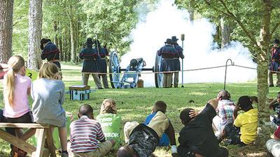
Local elementary school students watch as the cannon is fired at Horseshoe Bend National Military Park this past spring. The cannon will fire every 30 minutes starting at 10:30 a.m. with the last shot at 3:30 p.m at Saturday’s event. (Cliff Williams / The Outlook)
Local elementary school students watch as the cannon is fired at Horseshoe Bend National Military Park this past spring. The cannon will fire every 30 minutes starting at 10:30 a.m. with the last shot at 3:30 p.m at Saturday’s event. (Cliff Williams / The Outlook)
The Horseshoe Bend National Military Park will bring history to life this Saturday and give anyone who is interested a free chance to experience the lives and times of the Creek Indians, the Tennessee Militia and frontier families.
...STRONG THUNDERSTORMS WILL IMPACT EASTERN ELMORE...NORTHWESTERN
LEE...NORTHWESTERN MACON...CENTRAL TALLAPOOSA AND SOUTHEASTERN COOSA
COUNTIES THROUGH 830 PM CDT...

At 746 PM CDT, Doppler radar was tracking strong thunderstorms along
a line extending from Wind Creek State Park to near Kowaliga Bridge
to near Elmore. Movement was southeast at 45 mph.

HAZARD...Wind gusts up to 40 mph.

SOURCE...Radar indicated.

IMPACT...Gusty winds could knock down tree limbs and blow around
unsecured objects.

Locations impacted include...
Alexander City, Tuskegee, Tallassee, Dadeville, Camp Hill, Notasulga,
Kellyton, Equality, Milstead, Eclectic, Jacksons' Gap, Franklin,
Waverly, Martin Dam, Santuck, Cottage Grove, Reeves Airport, Tuskegee
National Forest, Ten Cedar Estates, and Nixburg.

PRECAUTIONARY/PREPAREDNESS ACTIONS...

If outdoors, consider seeking shelter inside a building.

Torrential rainfall is also occurring with these storms and may lead
to localized flooding. Do not drive your vehicle through flooded
roadways.

Frequent cloud to ground lightning is occurring with these storms.
Lightning can strike 10 miles away from a thunderstorm. Seek a safe
shelter inside a building or vehicle.

&&


MAX HAIL SIZE...0.00 IN;
MAX WIND GUST...40 MPH