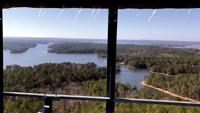
Ice hangs from the cab of the Smith Mountain Fire Tower. The view gives an overhead look of the area after a winter storm passed through, missing the area with snow. Pick up today’s Outlook for more images from last weekend’s ice in the area. (Cliff Williams / The Outlook)
Ice hangs from the cab of the Smith Mountain Fire Tower. The view gives an overhead look of the area after a winter storm passed through, missing the area with snow. Pick up today’s Outlook for more images from last weekend’s ice in the area. (Cliff Williams / The Outlook)
...RED FLAG WARNING IN EFFECT FROM 7 AM TO 7 PM CDT SATURDAY...

The National Weather Service in Birmingham has issued a Red Flag
Warning, which is in effect from 7 AM to 7 PM CDT Saturday. The
Fire Weather Watch is no longer in effect.

* WINDS...Northeast 10 to 20 mph with gusts up to 30 mph.

* RELATIVE HUMIDITY...As low as 18 percent.

* IMPACTS...The combination of a dry air mass and windy
conditions will result in critical fire weather conditions.
Outdoor burning is not recommended.

PRECAUTIONARY/PREPAREDNESS ACTIONS...

A Red Flag Warning means that critical fire weather conditions
are either occurring now....or will shortly. A combination of
strong winds...low relative humidity...and warm temperatures can
contribute to extreme fire behavior.

&&