A couple days before Thanksgiving severe storms are rolling in.
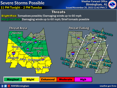
The National Weather Service issued a marginal severe weather risk from 11 p.m. tonight to 2 p.m. Tuesday for Tallapoosa and Coosa counties. The marginal risk includes possible damaging winds up to 60 mph and possible brief tornadoes.
.Widespread showers and storms are expected to develop once again
today along a stalled frontal boundary draped across Central
Alabama. High confidence exists for slow-moving storms capable of
producing very heavy rainfall on top of already saturated soils for
locations within the watch area.

...FLOOD WATCH IN EFFECT FROM 7 AM CDT THIS MORNING THROUGH THIS
EVENING...

* WHAT...Flooding caused by excessive rainfall on top of already
saturated soil conditions is possible.

* WHERE...A portion of central Alabama, including the following
counties, Autauga, Barbour, Bibb, Bullock, Chambers, Chilton,
Clay, Coosa, Dallas, Elmore, Fayette, Greene, Hale, Jefferson,
Lamar, Lee, Lowndes, Macon, Marengo, Montgomery, Perry, Pickens,
Pike, Randolph, Russell, Shelby, St. Clair, Sumter, Talladega,
Tallapoosa, Tuscaloosa and Walker.

* WHEN...From 7 AM CDT this morning through this evening.

* IMPACTS...Excessive runoff may result in flooding of rivers,
creeks, streams, and other low-lying and flood-prone locations.
Flooding may occur in poor drainage and urban areas. Area creeks
and streams are running high and could flood with more heavy rain.

* ADDITIONAL DETAILS...
- http://www.weather.gov/safety/flood

PRECAUTIONARY/PREPAREDNESS ACTIONS...

You should monitor later forecasts and be alert for possible Flood
Warnings. Those living in areas prone to flooding should be prepared
to take action should flooding develop.

&&